Trip to the ESRI EMEA User Conference, Munich, Germany: 23-25 Oct 2013.
Ever since I got the call from ESRI Ireland informing me that I, along with William Barry of Carlow County Council, had won the Maps Make Sense for Munich completion for the work we had done with ArcGIS online in building our new Map Portal in Roscommon I was really looking forward to attending the EMEA User Conference. With ESRI Ireland laying on flights, hotel accommodation, and access to the 3 day conference all I had to worry about was getting to the airport in time.
Tuesday 22nd
Got to the airport in plenty of time and met up with Willie. Had a chat about the conference programme and what sessions we planned to attend. The large number of talks and technical sessions taking place gave us a good idea of the scale of the conference. The conference website however had a tool that enabled us to book what sessions we planned to attend in advance and build our own personal agenda. Nice touch.
Both of us had decided to mainly concentrate on the technical sessions and see if we could build on our understanding of what we could achieve with the ArcGIS Server platform in our own Councils, as well as getting an idea of what new developments were coming down the road. Neither of us had been to Munich before so we were also very much looking forward to having a scout around. A small bit of disappointment that the Oktoberfest was already over, but then again maybe that wasn’t a bad thing.
Happy to say the flight went without a hitch and we got the train from Munich airport to just around the corner from the hotel. Dropped the bags in the room and then headed out for a bite to eat and a taste of proper German beer so surprised when the waiter dropped down two pints of San Miguel.
Wednesday 23rd
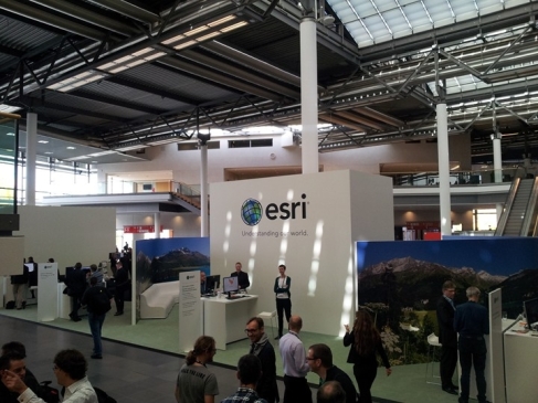
Next morning we shared a taxi to the Internal Congress Centre on the edge of the city where the Conference was being hosted. Must say first impressions were good. Plenty of staff around to assist and after registering, and getting our conference kit bag, we had a quick look around the venue to get our bearings. Again the size of the setup was impressive with approximately 60 exhibitors in addition to the ESRI stands, some of which were familiar such as Safe Software and con terra.
After a quick cup of coffee we attended a Round Table discussion on E-Government and Open Data, both of which are very topical in Ireland at the moment, and are very applicable to the Local Government sector on the basis of the amount of data we hold and the services we provide. Interesting to get other European viewpoints on these topics and how Open Data is being facilitated in other Countries. Details on the business cases around Open Data, and some ROI figures, were also very interesting.
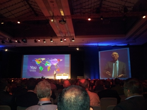
Met up with ESRI-Irelands Philip McLoughlin over lunch for a chat and we then attended the big event of the day which was the Opening Plenary, with the man himself Jack Dangermond discussing where ESRI is currently at and his vision for the future. Delighted to see a screen shot of the Roscommon Map Portal included in one of his slides. Again very impressive with a lot of emphasis put on the terms ‘Platform’ and ‘Web GIS’ and the building blocks which are the ‘Web Maps’ we are all now creating. This was followed with some live demonstrations of some of the new products and applications and some talks dealing with the effects of Globalisation and Climate Change and the role we all, as GIS people, have to play.
With the ESRI party scheduled for Thursday night we felt it was only wise to head back into the city centre for a bite to eat and to again try and sample a beer or two. Willie found the perfect spot in a traditional beer house with the added bonus of a few locals deciding to hold an impromptu German trad session. It would have been rude to leave.
Thursday the 24th
A day of technical workshops was ahead. First up was a session titled ‘ArcGIS for Mobile Overview’ which gave a good description of the new Collector app and how this moves GIS into the field through mobile devices. Again very applicable to Local Authorities where much information is being gathered and used by field staff daily. An overview of the Dashboard app was also provided which definitely looks to have potential in relation to integrating GIS into Management Information Systems.
Second session of the day gave an overview of ArcGIS 10.2 for Server. My first introduction to Server being 10.1, I probably didn’t appreciate the enhancements on display but I did gain a good understanding of the different configurations available and what best suits what scenario. Portal for Server was also explained and demonstrated which basically puts an ArcGIS online frontend onto Server. (Apologies but that is a very non-technical description and comes nowhere to doing it justice).
Another session attended was ‘ESRI Location Analytics’ which in a sense helped bring me back to the basics of what GIS can do for an organisation which is in the area of spatial analysis and assisting in making accurate decisions. What ESRI is doing however is integrating this functionality within existing business systems such as Microsoft Office, in turn making it more accessible to managers and decision makers. Final session of the day was in relation to building an ‘Effective GIS Technology Strategy’. Can’t say the brain was taking in too much at this stage but interesting and applicable all the same.
Then Party Time. Again very well organised with plenty of food and beer available. First beer Philip and myself grabbed turned out to be non-alcoholic. We didn’t make that mistake again. Wasn’t long until the band started up and not long after that until the dance floor started filling up. Needless to say the Irish contingent didn’t join in.
Friday the 25th
Last day and a short one at that with the conference officially closing at lunch time. I attended a technical session on using and customising the available ArcGIS Web Application Templates. I had already done some work with the Map Tour Storey Map template and I was interested to see what else was available. These templates enable you to present your work in a very slick and professional way with little effort. This helps you put the emphasis on your data on not the technology.
That was it then. After doing another circuit of the exhibition and having a chat with the Safe Software guys I headed for the exit (picking up a few more freebees on the way). Then five hours to explore Munich on foot before heading for the airport. From the bits I saw I can say Munich is a beautiful, friendly German city, with flavours of northern Italy thrown in. Easy to get around on foot and train and with much beautiful architecture and history you could easily spend a couple of days exploring it. If you had a few quid it also looks like’s a shoppers paradise. Definitely a city I will return to and the Oktoberfest is now firmly on the bucket list.
So thanks again to ESRI Ireland for putting up such a great prize. As a new enough ESRI user (convert) the conference really did help re-enforce my existing impression of ESRI as a key player and innovator in the area of GIS. I also like how the emphasis isn’t just on technology for technology sakes but how this can and should be applied by the likes of myself to help in dealing with the many problems that exist in the area around us, whether that’s how to deal with a local littering problem or on a larger scale how to deal with Climate Change.
Barry Doyle
GIS Officer
Roscommon County Council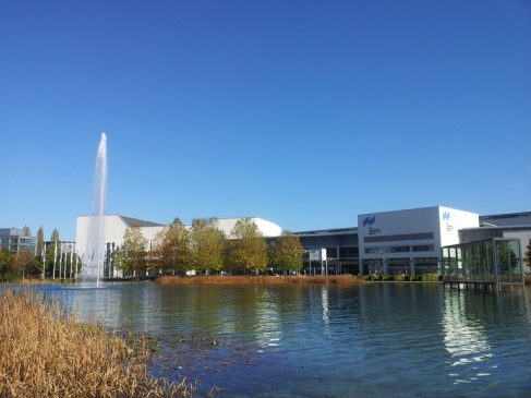


